My Experience
Sendero Cerro Guanaco (in English: Cerro Guanaco Trail) is located within the Tierra del Fuego National Park at the Southern tip of Argentina. Christian and I spent a few consecutive days in the park, taking our time to discover all it has to offer.
The track up to the top of Cerro Guanaco was part of our personal park exploration tour. My hiking career was still young back then and this would become the first hike to impose a challenge on me. Not only due to the trail itself but also due to the weather conditions that day.
We camped at one of the campgrounds between the Alakush Visitor’s Center and “el fin del mundo”, which is the end of Ruta 3. Argentina’s highway 3 is the most Southern established road and ends within the park. “El fin del mundo” is Spanish for “the end of the world”.
On the day we set out to do the Cerro Guanaco trail we first headed for the visitor’s center to warm up a bit. From the center it’s a little more than a kilometre to the official start of the Cerro Guanaco Trail. This hike can also be combined with the Hito XXIV Trail. This is a track that follows along the bank of Lago Acigami/Lago Roca all the way to the international border of Argentina and Chile.
There's a sign on the trail that shows you when to turn "right" (Northeast) for Sendero Cerro Guanaco or continue on the trail towards the border. From here it goes up, up and up.
The whole trail is reasonably steep and was, due to some rainfall prior and on the day itself, full of little adventures: a few river crossings and fields of knee deep mud. I considered the muddy parts fun as it challenged us to puzzle our way around rather than just following a given path.
The path is well marked with wee signs indicating distances, the first one being 4km (= 4km to the summit). There’s a marker for every one kilometre. Our personal perception was way off that day. When we reached the 3km marker it felt like we’ve already walked 3km instead of 1km. The few hikers we met on the trail had similar thoughts.
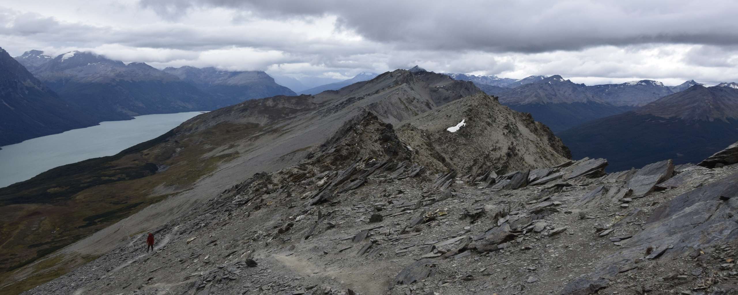
Given that this track was one of the first challenges of hiking to me I sometimes wonder how it would be walking it again with today’s level of experience. The final kilometre to the summit still remains one of the longest distances I've ever perceived. It seemed so endless. Walking one step forward, falling back two. Winds pushing towards me, making me slide down the scree that I walked on.
I was in awe with the diversity of the hike, especially given the low elevation. It felt like leveling our way up through the path. Starting with a steep forest bit, but protected from the wind. Then came mysteriously looking trees that seemed to want to confuse us off the path. Once we've had that quest mastered we had to make our way across a mud field. That's when climbing skills came in handy, hanging off from branches that saved us from sinking in too deeply.
And then, the final quest: The never ending kilometre...
More than once was I questioning why I was doing this. While making our way up, both of us were each to themselves, pushing forward, left with our own thoughts and only these. In my head I was creating a poetic story full of drama around this. Did I have to go all the way to the end of the world to face my limits, to be brought to my knees? Anything to keep my mind distracted from telling me to give up and "just" turn around - while my legs would keep moving. One step at a time.
And then again: Quiet but effective whispers of
"J u s t turn around..."
I was fatigued, the weather was draining, and the wind, oh the wind. My new nemesis. And yet, sooner than we knew it, we made it to the top.
Our initial plan was to have a nice coffee break on the summit to enjoy the views. But by the time we got there the weather was getting worse and worse. Wind was now accompanied by rain. We were busy trying to keep our balance instead of being blown off the mountain range. Despite this, the views were humbling. We were given a chance to look at the last bit of continuous land mass of the South, before there are only water and Antarctica. One of the many moments I remember giving a piece of my heart to the region that is called Patagonia.
Even with pretty madly looking clouds we could see as far as Ushuaia, the Beagle Channel, even a bit of Puerto WIlliams.
As you can see on the photos we did have our coffee break in a short “good” weather window on the way back.
Leave a comment*
(*Please see A word or two.)